Shift change in Cottbus-Nord opencast mine
After 30 years of lignite mining, the Cottbus-Nord opencast mine is transformed into a multi-purpose lake: the Cottbuser Ostsee. Construction measures of superlatives such as the shaping of the lake basin and the profiling of 26 kilometres of shoreline in total characterise the dimensions of the project.
In 2018, readiness for flooding the Cottbuser Ostsee was established. Since April 2019, water from the River Spree has been able to flow into the lake basin. In this way, what was once Lusatia’s smallest active opencast mine is being transformed into Brandenburg’s largest inland body of water and Germany’s largest post-mining lake.
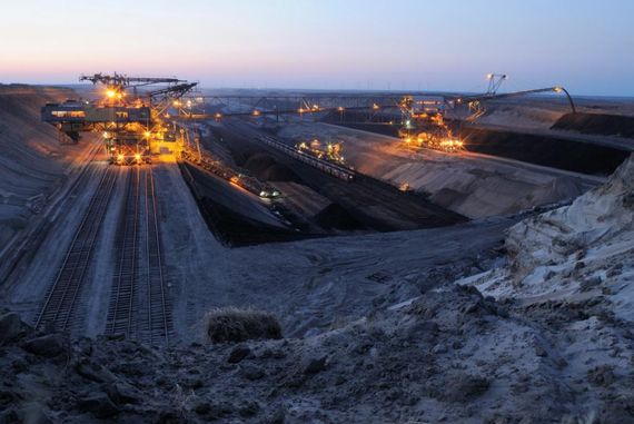
The Cottbus-Nord opencast mine
For over 30 years, Cottbus-Nord opencast mine as well as the neighbouring Jänschwalde opencast mine supplied the Jänschwalde power plant. Cottbus-Nord supplied around a quarter of the annual lignite required by the power plant, which at the time had a capacity of 3,000 megawatts. The lignite seam in this mine was about 45 metres deep and up to 11 metres thick. The first preparations for the exploration of the opencast mine, including the lowering of the groundwater level, began in the mid-1970s. On 8 April 1981, the first coal train entered the power plant and the last one on 23 December 2015. With the scheduled completion of coal mining, a new stage in the development of the post-mining landscape began for LEAG – the creation of a lake. It is primarily intended to serve as a leisure and holiday destination. In addition, the lake will be used for commercial fishing. The eastern shores are reserved for wildlife and nature.
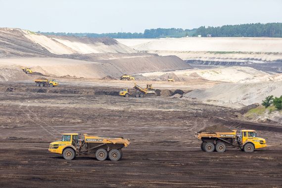
Landscape after mining
The lake basin was modelled from the dumps of the Cottbus-Nord opencast mine, requiring extensive earthworks. In order to be able to start this work unhindered, the complete infrastructure of the opencast mine and all large-scale equipment had to be dismantled directly after mining ended. In the future centre of the lake, around 20 million cubic metres of dumped soil were redistributed to ensure the safe future utilisation such as boat traffic and fishing. The earth masses removed were used to backfill the former coal railway exit and to create Bärenbrücker Bucht (Bärenbrücker Bay). About 140 earthwork machines were used daily at the large construction site of the Cottbuser Ostsee.
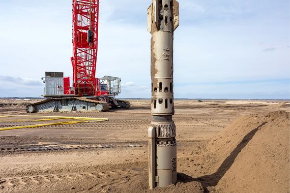
Safe shorelines
The work on securing of the shoreline areas began parallel. For this purpose, the naturally grown shores in the south, west and north, which were not influenced by mining, were profiled and flattened. The eastern shore and its offshore islands were established using opencast mining equipment. Thereafter additional stabilisation measures were necessary. The well-proven technologies of vibrocompaction and drop-weight compaction were used to secure these banks, compacting the loosely deposited sands to depths of up to 50 metres. The resulting subterranean barrier is about 120 metres wide and has a total length of approx. 16 kilometres, a solid ground structure, giving the slopes of the shores lasting stability. A total of 46 million cubic metres of soil have been compacted in this way.

Water for the Cottbuser Ostsee
It has been permitted to withdraw more than 80 percent of the required water from the Spree River according to the approval of the State of Brandenburg. Less than 20 percent will originate from rising groundwater. Flooding is an integral part of regional water management in the Spree catchment area and is subject to fixed rules. When and how much Spree water may be discharged for the Ostsee is determined by weekly flooding control instructions.
These are issued by the Water Management Center of the Lusatian Mining District and agreed with the state authorities. The particular interests of the residents along the Spree River and the protection of its fauna and flora are taken into consideration. This means, water is only taken from the Spree when the river carries enough water. This is mainly the case in the winter months or when summer floods occur.
for stabilisation of target water level
The flooding
Flooding began in April 2019. Here you can find the current weekly figures on the water level and the proportion of Spree water – provided that water withdrawal from the Spree is not paused.

For Cottbuser Ostsee Lake, no water withdrawal from the River Spree is currently designated. The second phase for stabilising the target water level has therefore ended. In total, since 10 November 2025, around 9.5 million m³ of Spree water has been discharged into Cottbuser Ostsee over 129 days, averaging 0.8 m³/s.
The flooding waters are withdrawn from the Spree River via the Hammergraben at the level of the Lakoma weir. For the water withdrawal, a so-called "overflow structure" with a maximum capacity of 5,000 litres per second was erected. From there, the water flows through a subterranean feeder at a downward gradient to the inlet structure. The inlet structure is below a visitor's platform. The water for flooding flows out of the pipeline of the feeder into the former opencast mine. In the future, a steerable outflow structure for the lake, which is to be errected east of Willmersdorf, will ensure a connection to the regional water network via the Schwarzen Graben. It makes use of the natural gradient of the terrain.
By means of a special flooding management system using Spree River water and good quality groundwater, the Cottbuser Ostsee Lake is predicted to have a water quality which does not require additional improvement measures. Thus, even dry periods of several years in which the Spree holds little water can be managed. This assessment is supported by measured pH values of 7 to 7.8. Water visibility depths will range between six and eight metres.
The target water level of Cottbuser Ostsee Lake is 62.5 metres above sea level (NHN), with a fluctuation range between 61.8 and 63.5 metres NHN. Even up to one metre above and two metres below this fluctuation range, a gently contoured shoreline end profile prevents damage caused by the lake’s wave action.

Experience postmining landscape
Between the Spreewald in the north and the Seenland in the south, the Cottbuser Ostsee Lake sets a new destination on the map of Lusatia. The interest of the future "coastal towns" in opening up the lake for future tourist use is correspondingly high.
The ideas of the surrounding communities are very diverse. They range from the construction of ports and water skiing facilities to the development of cycle paths and infrastructure to the regulation of navigability.
The size of the lake also makes it possible to install floating photovoltaics without restricting its use for local recreation and tourism.
The eastern shore of the lake offers areas for nature and landscape development. With its richly structured island and shallow water areas, it provides fauna and flora with individual habitats. Among others, waterfowl such as Bean geese and White-fronted geese, Grey herons and Great Crested Grebes, will find places to rest and hunting grounds for food.


A Cottbuser Ostsee tour
At the Cottbuser Ostsee Lake, a network of cycle paths is being created, that will connect the lakeshore areas with interesting sites to explore in the Lusatian regiont and in the vicinity of the post-mining landscape. With due caution, various lookout points can be visited during the flooding time. The "Fürst-Pückler-Radweg" leads from Cottbus directly to the edge of the former opencast mine. There are information boards at intervals, pointing out the change in the landscape with interesting information on mining and the regional history, for visitors following the future shoreline between Neuendorf, Merzdorf and Schlichow. A worthwhile destination for a great panoramic view is the lookout tower in Merzdorf. From a height of 30 metres, visitors have an impressive view showing the dimensions of the overall "Cottbuser Ostsee" project. A viewing platform directly above the water feeder awaits the guests at the inlet structure.
Use permitted only after official approval
At the end of 2024, Cottbuser Ostsee Lake reached its target water level for the first time. Depending on water availability, the lake level will continue to be supported with water from the River Spree in order, among other things, to completely fill the pore spaces of the inner dump. Further measures on the ‘Ostsee landscape construction site’ include shoreline stabilisation and the construction of the outflow structure.

The 19‑square‑kilometre lake with its 26‑kilometre shoreline will only be accessible to the public once official authorisation for use has been granted. Until then, access remains prohibited.